TEP’s Conwy Green Infrastructure Assessment was selected as one of the eight finalists at the RTPI Cymru Awards for Planning Excellence. The awards highlight exceptional examples of how planning and planners have a positive impact on our quality of life by creating exceptional places and protecting our environment. In recognising and rewarding excellence, the awards aim to inspire others to achieve the same high standards. TEP is very pleased to announce that their project received Highly Commended with Roisin Willmott Director of RTPI Cymru saying: “[The project] shows the significance of GIA setting a framework for development, and not an afterthought.” We are proud of the project and hope that this study paves the way for a greener Wales!
The Conwy Green Infrastructure Assessment (GIA) is one of the first of such studies undertaken in Wales and it aligns with Natural Resources Wales North West Wales Area Statement. From 2021 the undertaking of a GIA will be mandatory for all Welsh local authorities and the Conwy GIA will provide a good model for other local authorities to work to. The Green Infrastructure Assessment, commissioned by Conwy County Borough Council, will guide the delivery of a greener, healthier, more biodiverse, and prosperous Conwy. It will set the baseline for green infrastructure and go on to inform the Council’s Replacement Local Development Plan 2018-2033, creating the basis for development briefs and requirements.
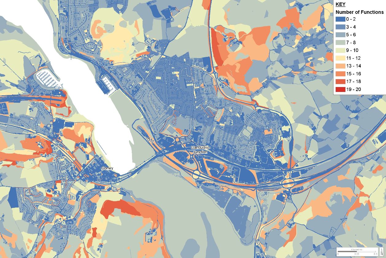
The brief required the mapping of Conwy’s green infrastructure (GI) resource, including an analysis of multi-functionality. It also required a vision and themes for GI in the county borough to be informed by policy and stakeholder consultation. The integrated project team of town planners, landscape architects, urban designers, ecologists and GIS analysts reviewed key policy documents, engaged in stakeholder consultation and mapped and analysed data. Our GIS analysis team produced innovative ‘heat’ maps highlighting areas of greatest functionality across the study, with more detailed insets for the urban areas. Our comprehensive chapter on policy context informed the vision and themes for GI and these have defined the approach to establishing where GI needs to be protected, enhanced or created. These analysis plans were presented for each of the five themes:
The recommendations of the GIA, which include enabling suitable GI in key locations, are being taken forward by Conwy Council’s delivery teams and partners. These include tree planting operations on lower-grade agricultural land, which will limit soil erosion and surface water run-off in the upper catchment of the Rivers Dulas, Elwy, Conwy and Dee. The Council is also actioning the recommendations of the GIA in terms of nature recovery networks. This includes linking up statutorily protected sites (eg. Sites of Special Scientific Interest (SSSI) and Conwy Wildlife site), with sites of biodiversity priority, watercourse corridors and floodplains. Nature recovery networks have increasing importance, as wildlife species will come under increasing pressure from more extreme climate events and patterns and will need to commute for foraging, feeding and breeding. The recommendations have increased rigour as they include the mapping of key bird assemblages and important bat foraging areas, according to data received from the local records centre (Cofnod). Together, these areas will aid in the delivery of bigger, better and more joined-up benefits for biodiversity in Conwy.
If you would like to learn more about the project or how our Environmental Planning Team can help you and your project, please get in touch by emailing planning@tep.uk.com. You can also read other articles from the team here.