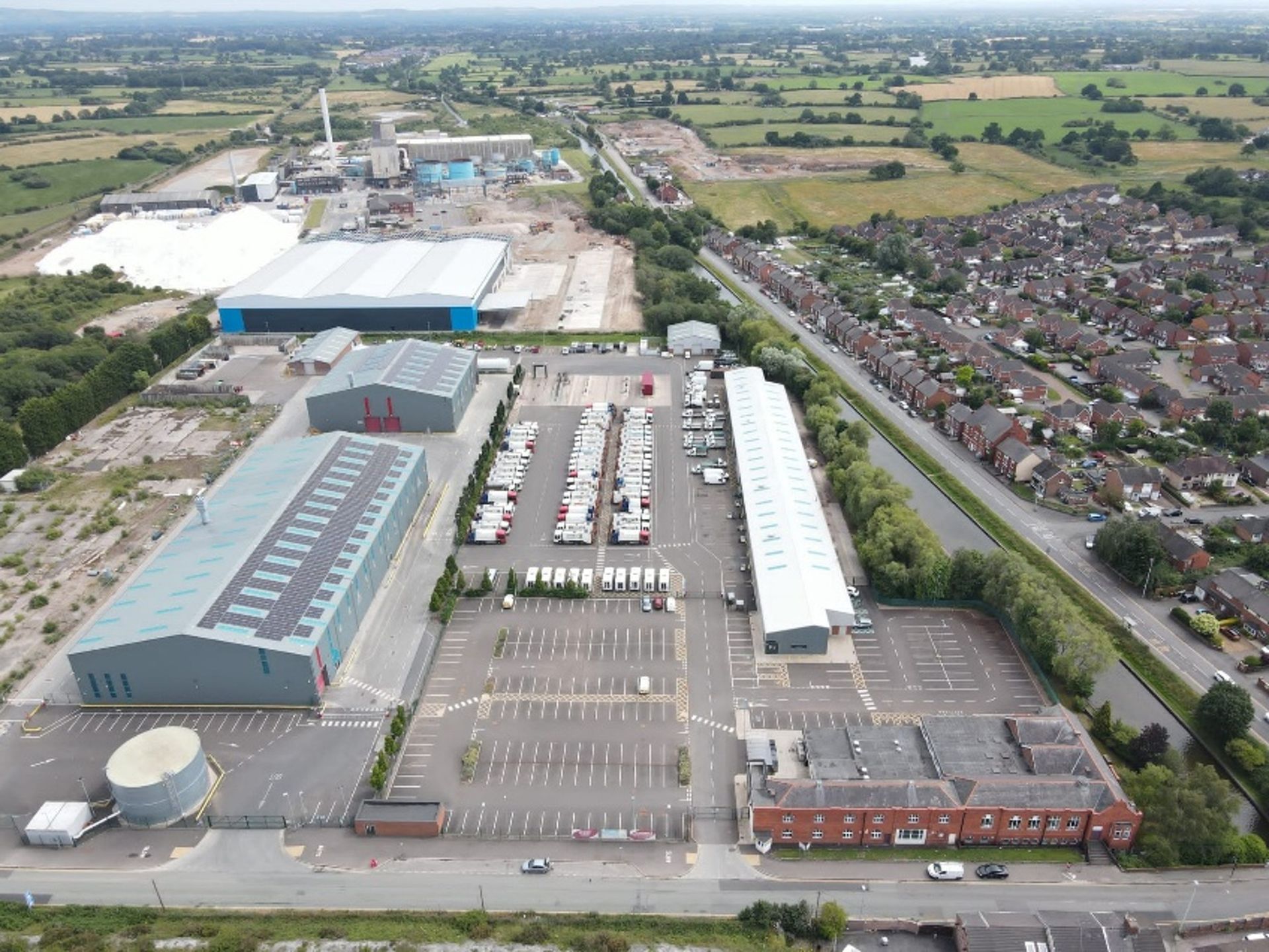
On behalf of Cheshire East Council, TEP has secured consent for the expansion of the Environmental Services Hub site. The expansion will facilitate a weekly food waste collection service for every property in the borough, helping Cheshire East Council prepare for a new statutory requirement from central government due to come into force from 2026-2027. To achieve this, we prepared and managed three planning applications: A full application for 84 new employee parking spaces, a bin storage area and a security lodge; A non-material amendment application for the reconfiguration of the existing site layout; and A variation of condition application to increase the limit on vehicle movements. The project began with a pre-application advice request, followed by discussions with the local planning authority to confirm the applications and supporting information required for submission. A key element of the project was the preparation of a planning needs case. This justified the development remaining at the Environmental Services Hub site, rather than a 'preferred site' identified within the council's Waste Plan. The case also identified the benefits of increasing recycling rates and supporting sustainable waste management across the borough. To support the applications, traffic surveys were commissioned and a Transport Statement was prepared, demonstrating that the proposals would have no negative impact on the local highway network. A Transport Note was also produced to establish the number of vehicle movements that should be permitted through the variation of condition application. Air quality and noise assessments were also undertaken to demonstrate that impacts would be limited and acceptable.
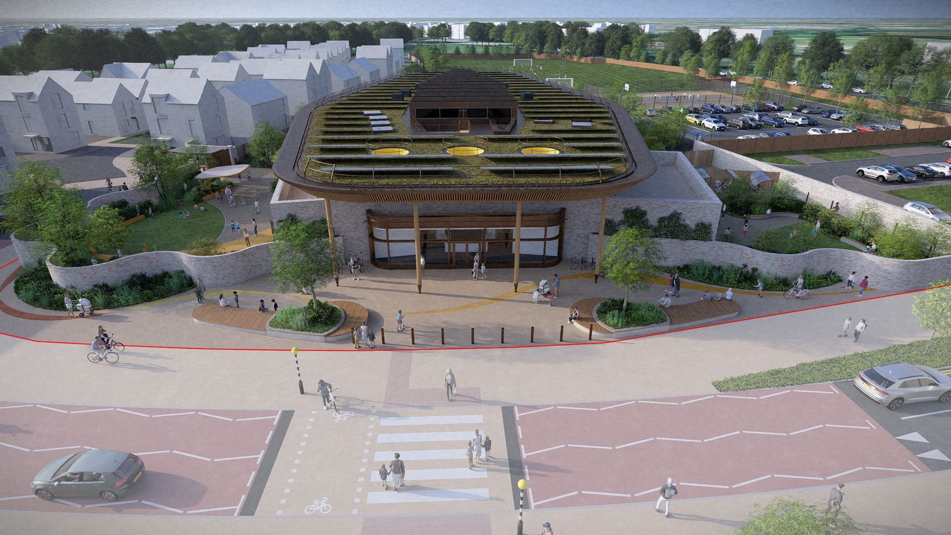
Plans for Brookleigh Primary School have received unanimous planning approval at Mid Sussex District Council's District Planning Committee on 28th May 2026. The new school, located to the east of Isaacs Lane, will provide 420 student places, alongside a 52-place nursery and a 16-place Special Support Centre. As a two-form entry school, it will support two classes per year group. This marks a proud first for Homes England as master developer, directly delivering new school places for the Brookleigh community. TEP worked in partnership with the wider project team, including CampbellReith, sixfootstudio, Fabrik, FLOH and Stace, to help bring the proposals forward. Supporting the Delivery of a New School TEP's Planning team co-ordinated the preparation of the reserved matters application, including pre-application discussions and community consultation, while our Ecology team completed site surveys and advised on Biodiversity Net Gain (BNG). A key part of our role was ensuring that local people and stakeholders had opportunities to engage with the proposals as they developed. In preparation for the application submission, we organised public consultation events and prepared consultation materials explaining the scheme, masterplan, access strategy, landscaping, and the proposed layout and appearance of the school. Two public exhibitions were held at an accessible venue close to the site, providing an opportunity for the local community to discuss the proposals, ask questions and share feedback. We also organised an information leaflet drop to approximately 4,000 homes and established an online consultation portal to enable people to engage digitally. The feedback received was largely positive, reflecting both the demand for new school places and the work undertaken by the project team to develop a modern, sustainable design for the Brookleigh community.

We have been proud to support the regeneration of the Grade II Listed Earlestown Town Hall, one of the most historically and visually significant buildings in the town centre. Dating from the late 19th century, the Flemish-inspired civic building occupies a commanding position within Earlestown and has long served as a local landmark and community venue. Over the years, the Town Hall has played host to generations of local events and performances, including an appearance by The Beatles during the early years of their rise to fame. Commissioned by ECF, we provided heritage and archaeology consultancy services to support the redevelopment and restoration of the building as part of wider regeneration ambitions for Earlestown town centre. Working as part of a multidisciplinary team, we offered heritage advice throughout the pre-application stage, helping to shape proposals that would be sympathetic to the building’s historic character while enabling it to meet modern community needs.

Explore what the Energy Independence Bill could mean for renewable energy, planning reform and UK infrastructure projects.

If you are planning a development, managing land, or need advice on great crested newts or other protected species, contact us today.
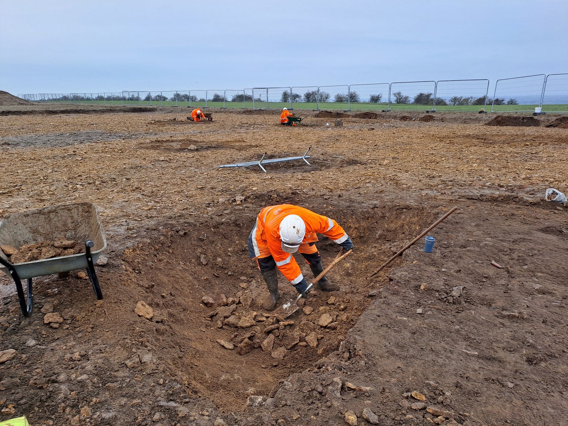
Delivering major infrastructure in sensitive environments requires a coordinated approach, bringing together a range of expertise to understand place, manage risk and support informed decision-making. Our work on the North Hykeham Relief Road (NHRR) in Lincolnshire is a strong example of this in practice, with teams from across TEP working together to support the delivery of this long-planned scheme. A long-planned piece of infrastructure The NHRR forms the final section of Lincoln’s ring road, a scheme that has been identified in Local Plans for around twenty years. As the project progressed, it required careful consideration of environmental constraints, historic assets and landscape character, alongside the practicalities of delivering a major new road. Working alongside Balfour Beatty and the wider project team, we provided a range of services spanning heritage and archaeology, planning, landscape, ecology and arboriculture. A coordinated programme of assessment and support underpinned the development of the scheme. Our Historic Environment team established the baseline through desk-based assessment, consultation and phased archaeological evaluation. This work identified areas of interest including sites of prehistoric activity, the important Roman road of Ermine Street, and a potential Roman villa complex, providing valuable insight into the long-term history of the site. These findings directly informed the design process, helping to shape the scheme in response to the site’s archaeological and historical context. The team also assessed potential impacts on sensitive heritage assets, including listed buildings and conservation areas, ensuring that the historic environment was fully considered as the project evolved.

Bringing the world of books to life for blind or visually impaired children

TEP is proud to be partnered with the award-winning initiative Time for Geograph y, whic h showcases the importance of geography and the diverse careers it can lead to. Time for Geography is a free, online education platform reaching schools and universities across the UK. Through a series of engaging video resources, it brings geography to life in the classroom, connecting academic learning with real-world challenges such as sustainability, climate change, urban planning and environmental management. Our contribution to the initiative forms part of the platform’s Careers Collection, where our team shares insight into the varied and rewarding pathways geography can open up. These resources are designed to help students understand how their studies translate into professional roles, offering a clearer view of the opportunities available within the environmental sector. We’re delighted that this collaboration has been recognised with a Highly Commended Geographical Association Publishers Award , which celebrates the careers-focused videos and resources developed to guide students towards further education and careers in our industry. With an audience of over 2.5 million this year, Time for Geography is a powerful example of how education and industry can come together to inspire future talent, showing how a subject studied in the classroom can lead to meaningful, real-world careers. For many of our colleagues at TEP, that journey began with a simple interest in geography at school. Today, that interest has grown into careers spanning ecology, arboriculture, heritage, planning, landscape design and environmental management. By sharing these experiences, we hope to encourage the next generation to see geography not only as a fascinating subject, but as a pathway into work that makes a tangible difference. We’re proud to support an initiative that is helping shape the future talent pipeline for our sector, and to inspire the environmental specialists of tomorrow. Learn more and watch our video:
Changes to the Planning Inspectorate’s Procedural Guide will update how planning appeals are handled in England for applications submitted after 1st April 2026.

TEP was commissioned by Natural England to carry out a detailed chalk scrub study across the Seven Sisters National Nature Reserve.
TEP supported Moor Allerton Golf Club in exploring the opportunity to establish a habitat bank across areas of land identified as surplus to operational requirements.
TEP was commissioned to undertake a two-stage historic environment baseline study and heritage impact assessment within the Tatton Meres SSSI.
On behalf of Cheshire East Council, TEP has secured consent for the expansion of the Environmental Services Hub site. The expansion will facilitate a weekly food waste collection service for every property in the borough, helping Cheshire East Council prepare for a new statutory requirement from central government due to come into force from 2026-2027. To achieve this, we prepared and managed three planning applications: A full application for 84 new employee parking spaces, a bin storage area and a security lodge; A non-material amendment application for the reconfiguration of the existing site layout; and A variation of condition application to increase the limit on vehicle movements. The project began with a pre-application advice request, followed by discussions with the local planning authority to confirm the applications and supporting information required for submission. A key element of the project was the preparation of a planning needs case. This justified the development remaining at the Environmental Services Hub site, rather than a 'preferred site' identified within the council's Waste Plan. The case also identified the benefits of increasing recycling rates and supporting sustainable waste management across the borough. To support the applications, traffic surveys were commissioned and a Transport Statement was prepared, demonstrating that the proposals would have no negative impact on the local highway network. A Transport Note was also produced to establish the number of vehicle movements that should be permitted through the variation of condition application. Air quality and noise assessments were also undertaken to demonstrate that impacts would be limited and acceptable.
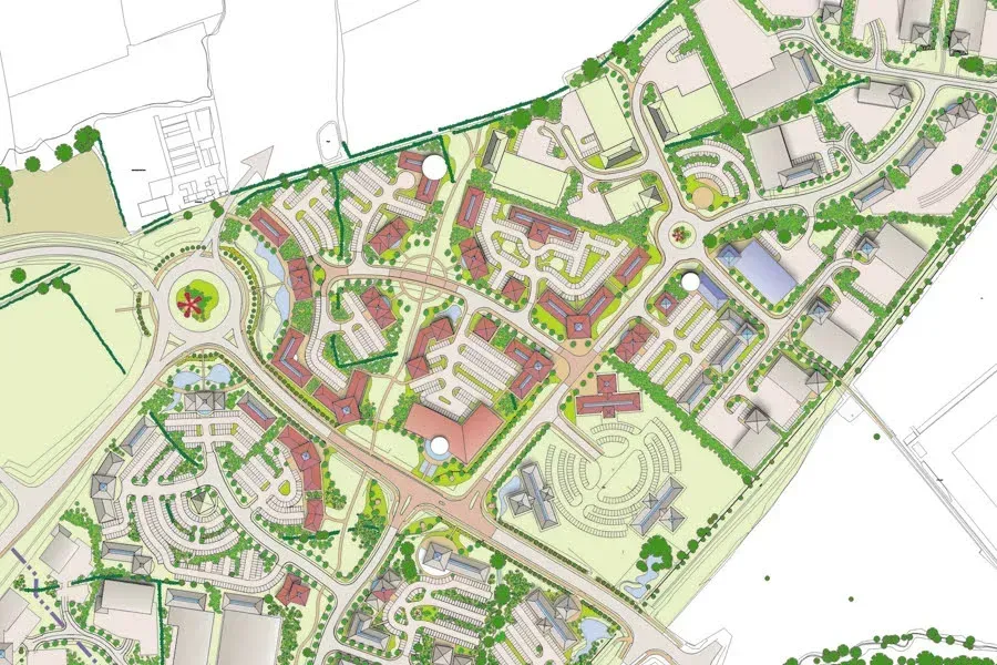
Plans for Brookleigh Primary School have received unanimous planning approval at Mid Sussex District Council's District Planning Committee on 28th May 2026. The new school, located to the east of Isaacs Lane, will provide 420 student places, alongside a 52-place nursery and a 16-place Special Support Centre. As a two-form entry school, it will support two classes per year group. This marks a proud first for Homes England as master developer, directly delivering new school places for the Brookleigh community. TEP worked in partnership with the wider project team, including CampbellReith, sixfootstudio, Fabrik, FLOH and Stace, to help bring the proposals forward. Supporting the Delivery of a New School TEP's Planning team co-ordinated the preparation of the reserved matters application, including pre-application discussions and community consultation, while our Ecology team completed site surveys and advised on Biodiversity Net Gain (BNG). A key part of our role was ensuring that local people and stakeholders had opportunities to engage with the proposals as they developed. In preparation for the application submission, we organised public consultation events and prepared consultation materials explaining the scheme, masterplan, access strategy, landscaping, and the proposed layout and appearance of the school. Two public exhibitions were held at an accessible venue close to the site, providing an opportunity for the local community to discuss the proposals, ask questions and share feedback. We also organised an information leaflet drop to approximately 4,000 homes and established an online consultation portal to enable people to engage digitally. The feedback received was largely positive, reflecting both the demand for new school places and the work undertaken by the project team to develop a modern, sustainable design for the Brookleigh community.
We have been proud to support the regeneration of the Grade II Listed Earlestown Town Hall, one of the most historically and visually significant buildings in the town centre. Dating from the late 19th century, the Flemish-inspired civic building occupies a commanding position within Earlestown and has long served as a local landmark and community venue. Over the years, the Town Hall has played host to generations of local events and performances, including an appearance by The Beatles during the early years of their rise to fame. Commissioned by ECF, we provided heritage and archaeology consultancy services to support the redevelopment and restoration of the building as part of wider regeneration ambitions for Earlestown town centre. Working as part of a multidisciplinary team, we offered heritage advice throughout the pre-application stage, helping to shape proposals that would be sympathetic to the building’s historic character while enabling it to meet modern community needs.
Explore what the Energy Independence Bill could mean for renewable energy, planning reform and UK infrastructure projects.
If you are planning a development, managing land, or need advice on great crested newts or other protected species, contact us today.
Delivering major infrastructure in sensitive environments requires a coordinated approach, bringing together a range of expertise to understand place, manage risk and support informed decision-making. Our work on the North Hykeham Relief Road (NHRR) in Lincolnshire is a strong example of this in practice, with teams from across TEP working together to support the delivery of this long-planned scheme. A long-planned piece of infrastructure The NHRR forms the final section of Lincoln’s ring road, a scheme that has been identified in Local Plans for around twenty years. As the project progressed, it required careful consideration of environmental constraints, historic assets and landscape character, alongside the practicalities of delivering a major new road. Working alongside Balfour Beatty and the wider project team, we provided a range of services spanning heritage and archaeology, planning, landscape, ecology and arboriculture. A coordinated programme of assessment and support underpinned the development of the scheme. Our Historic Environment team established the baseline through desk-based assessment, consultation and phased archaeological evaluation. This work identified areas of interest including sites of prehistoric activity, the important Roman road of Ermine Street, and a potential Roman villa complex, providing valuable insight into the long-term history of the site. These findings directly informed the design process, helping to shape the scheme in response to the site’s archaeological and historical context. The team also assessed potential impacts on sensitive heritage assets, including listed buildings and conservation areas, ensuring that the historic environment was fully considered as the project evolved.
Bringing the world of books to life for blind or visually impaired children
TEP is proud to be partnered with the award-winning initiative Time for Geograph y, whic h showcases the importance of geography and the diverse careers it can lead to. Time for Geography is a free, online education platform reaching schools and universities across the UK. Through a series of engaging video resources, it brings geography to life in the classroom, connecting academic learning with real-world challenges such as sustainability, climate change, urban planning and environmental management. Our contribution to the initiative forms part of the platform’s Careers Collection, where our team shares insight into the varied and rewarding pathways geography can open up. These resources are designed to help students understand how their studies translate into professional roles, offering a clearer view of the opportunities available within the environmental sector. We’re delighted that this collaboration has been recognised with a Highly Commended Geographical Association Publishers Award , which celebrates the careers-focused videos and resources developed to guide students towards further education and careers in our industry. With an audience of over 2.5 million this year, Time for Geography is a powerful example of how education and industry can come together to inspire future talent, showing how a subject studied in the classroom can lead to meaningful, real-world careers. For many of our colleagues at TEP, that journey began with a simple interest in geography at school. Today, that interest has grown into careers spanning ecology, arboriculture, heritage, planning, landscape design and environmental management. By sharing these experiences, we hope to encourage the next generation to see geography not only as a fascinating subject, but as a pathway into work that makes a tangible difference. We’re proud to support an initiative that is helping shape the future talent pipeline for our sector, and to inspire the environmental specialists of tomorrow. Learn more and watch our video:
Changes to the Planning Inspectorate’s Procedural Guide will update how planning appeals are handled in England for applications submitted after 1st April 2026.
TEP was commissioned by Natural England to carry out a detailed chalk scrub study across the Seven Sisters National Nature Reserve.
TEP supported Moor Allerton Golf Club in exploring the opportunity to establish a habitat bank across areas of land identified as surplus to operational requirements.
TEP was commissioned to undertake a two-stage historic environment baseline study and heritage impact assessment within the Tatton Meres SSSI.
On behalf of Cheshire East Council, TEP has secured consent for the expansion of the Environmental Services Hub site. The expansion will facilitate a weekly food waste collection service for every property in the borough, helping Cheshire East Council prepare for a new statutory requirement from central government due to come into force from 2026-2027. To achieve this, we prepared and managed three planning applications: A full application for 84 new employee parking spaces, a bin storage area and a security lodge; A non-material amendment application for the reconfiguration of the existing site layout; and A variation of condition application to increase the limit on vehicle movements. The project began with a pre-application advice request, followed by discussions with the local planning authority to confirm the applications and supporting information required for submission. A key element of the project was the preparation of a planning needs case. This justified the development remaining at the Environmental Services Hub site, rather than a 'preferred site' identified within the council's Waste Plan. The case also identified the benefits of increasing recycling rates and supporting sustainable waste management across the borough. To support the applications, traffic surveys were commissioned and a Transport Statement was prepared, demonstrating that the proposals would have no negative impact on the local highway network. A Transport Note was also produced to establish the number of vehicle movements that should be permitted through the variation of condition application. Air quality and noise assessments were also undertaken to demonstrate that impacts would be limited and acceptable.
Plans for Brookleigh Primary School have received unanimous planning approval at Mid Sussex District Council's District Planning Committee on 28th May 2026. The new school, located to the east of Isaacs Lane, will provide 420 student places, alongside a 52-place nursery and a 16-place Special Support Centre. As a two-form entry school, it will support two classes per year group. This marks a proud first for Homes England as master developer, directly delivering new school places for the Brookleigh community. TEP worked in partnership with the wider project team, including CampbellReith, sixfootstudio, Fabrik, FLOH and Stace, to help bring the proposals forward. Supporting the Delivery of a New School TEP's Planning team co-ordinated the preparation of the reserved matters application, including pre-application discussions and community consultation, while our Ecology team completed site surveys and advised on Biodiversity Net Gain (BNG). A key part of our role was ensuring that local people and stakeholders had opportunities to engage with the proposals as they developed. In preparation for the application submission, we organised public consultation events and prepared consultation materials explaining the scheme, masterplan, access strategy, landscaping, and the proposed layout and appearance of the school. Two public exhibitions were held at an accessible venue close to the site, providing an opportunity for the local community to discuss the proposals, ask questions and share feedback. We also organised an information leaflet drop to approximately 4,000 homes and established an online consultation portal to enable people to engage digitally. The feedback received was largely positive, reflecting both the demand for new school places and the work undertaken by the project team to develop a modern, sustainable design for the Brookleigh community.
We have been proud to support the regeneration of the Grade II Listed Earlestown Town Hall, one of the most historically and visually significant buildings in the town centre. Dating from the late 19th century, the Flemish-inspired civic building occupies a commanding position within Earlestown and has long served as a local landmark and community venue. Over the years, the Town Hall has played host to generations of local events and performances, including an appearance by The Beatles during the early years of their rise to fame. Commissioned by ECF, we provided heritage and archaeology consultancy services to support the redevelopment and restoration of the building as part of wider regeneration ambitions for Earlestown town centre. Working as part of a multidisciplinary team, we offered heritage advice throughout the pre-application stage, helping to shape proposals that would be sympathetic to the building’s historic character while enabling it to meet modern community needs.
Explore what the Energy Independence Bill could mean for renewable energy, planning reform and UK infrastructure projects.
If you are planning a development, managing land, or need advice on great crested newts or other protected species, contact us today.
Delivering major infrastructure in sensitive environments requires a coordinated approach, bringing together a range of expertise to understand place, manage risk and support informed decision-making. Our work on the North Hykeham Relief Road (NHRR) in Lincolnshire is a strong example of this in practice, with teams from across TEP working together to support the delivery of this long-planned scheme. A long-planned piece of infrastructure The NHRR forms the final section of Lincoln’s ring road, a scheme that has been identified in Local Plans for around twenty years. As the project progressed, it required careful consideration of environmental constraints, historic assets and landscape character, alongside the practicalities of delivering a major new road. Working alongside Balfour Beatty and the wider project team, we provided a range of services spanning heritage and archaeology, planning, landscape, ecology and arboriculture. A coordinated programme of assessment and support underpinned the development of the scheme. Our Historic Environment team established the baseline through desk-based assessment, consultation and phased archaeological evaluation. This work identified areas of interest including sites of prehistoric activity, the important Roman road of Ermine Street, and a potential Roman villa complex, providing valuable insight into the long-term history of the site. These findings directly informed the design process, helping to shape the scheme in response to the site’s archaeological and historical context. The team also assessed potential impacts on sensitive heritage assets, including listed buildings and conservation areas, ensuring that the historic environment was fully considered as the project evolved.
Bringing the world of books to life for blind or visually impaired children
TEP is proud to be partnered with the award-winning initiative Time for Geograph y, whic h showcases the importance of geography and the diverse careers it can lead to. Time for Geography is a free, online education platform reaching schools and universities across the UK. Through a series of engaging video resources, it brings geography to life in the classroom, connecting academic learning with real-world challenges such as sustainability, climate change, urban planning and environmental management. Our contribution to the initiative forms part of the platform’s Careers Collection, where our team shares insight into the varied and rewarding pathways geography can open up. These resources are designed to help students understand how their studies translate into professional roles, offering a clearer view of the opportunities available within the environmental sector. We’re delighted that this collaboration has been recognised with a Highly Commended Geographical Association Publishers Award , which celebrates the careers-focused videos and resources developed to guide students towards further education and careers in our industry. With an audience of over 2.5 million this year, Time for Geography is a powerful example of how education and industry can come together to inspire future talent, showing how a subject studied in the classroom can lead to meaningful, real-world careers. For many of our colleagues at TEP, that journey began with a simple interest in geography at school. Today, that interest has grown into careers spanning ecology, arboriculture, heritage, planning, landscape design and environmental management. By sharing these experiences, we hope to encourage the next generation to see geography not only as a fascinating subject, but as a pathway into work that makes a tangible difference. We’re proud to support an initiative that is helping shape the future talent pipeline for our sector, and to inspire the environmental specialists of tomorrow. Learn more and watch our video:
Changes to the Planning Inspectorate’s Procedural Guide will update how planning appeals are handled in England for applications submitted after 1st April 2026.
TEP was commissioned by Natural England to carry out a detailed chalk scrub study across the Seven Sisters National Nature Reserve.
TEP supported Moor Allerton Golf Club in exploring the opportunity to establish a habitat bank across areas of land identified as surplus to operational requirements.
TEP was commissioned to undertake a two-stage historic environment baseline study and heritage impact assessment within the Tatton Meres SSSI.